


Overview of Chandigarh’s Planning

The first Prime Minister of India, Jawaharlal Nehru, dreamed of Chandigarh to be a project of modernity and progress. This mandate was put in front of the American architects Albert Mayer and Matthew Nowicki. The duo started working on the plan of the Golden City Model, but in an unexpected accident, Matthew Nowicki died in August 1950, following this event Albert Mayer also withdrew from this project. This made the project halt.

So, the directors of the Chandigarh Capital Project went to Europe to search for some other architect to restart the project. There they met the Swiss-French architect Le Corbusier, who agreed to work for Chandigarh along with his cousin, Pierre Jeanneret as site architect.
Le Corbusier could have just worked to fill in the gaps of the incomplete project, instead, he worked ahead to create his master design. With the roads conforming to the terrain of the site, the curvature of Mayer’s fan-shaped concept was reworked into the grid with curves so shallow as to nearly be orthogonal. Series of roads are built-in hierarchies ranging from arterial roads to bicycle paths. The roadway grids are bounded by large sectors, which even feature a greenspace along the north-south axis across the commercial road running from east-west. This new layout designed by Le Corbusier compressed Mayer’s 6908 acres down to 5380 acres, hence increasing the density of the city by 20% while still respecting the principles of the Garden City Movement.
Le Corbusier culminated his life in the city of Chandigarh. This city is designed to be like a man; which is hard and assertive, and not gentle; it is riddled with mistakes made not in error but arrogance; it is not practical; it is unforgettable. Le Corbusier adored the Mediterranean and has now found fulfillment in the scorching heat of India with this project.

Geographical Location of Chandigarh
The city of Chandigarh is bound by two seasonal rivulets, viz., Patiali Rao in the northwest and the Sukhna in the southeast. In the northeast, it extends up to the foothills of the Shivaliks. The city experiences an extreme climate, with the maximum temperature rising to 45° in summers and the minimum temperature dropping to 3° in winters. The prevailing wind is from the southeast to the northwest in summer and vice versa in winter.

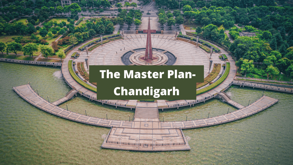
The Master Plan of Chandigarh
The master plan of Chandigarh as designed by Le Corbusier was according to the design of the ‘Human Body’.
- Head – The Capitol Complex
- Heart – The City Centre
- Lungs – The Leisure Valley, Open Spaces, and Sector Greens
- Intellect – The Educational and Cultural Institutions
- Circulatory system – The Network of Roads, the 8Vs
- Viscera – The Industrial Area
Living, working, circulation, and care for body and soul, were the four main basic functions of the city as identified by Le Corbusier. Circulation is one of the major priorities of Le Corbusier, was catered to by creating hierarchical roads such that easy movement can be ensured along with tranquil and safe living spaces.

The entire city is divided into 63 sectors, where each sector or neighbored unit is similar to Indian ‘mohallas’. The primary sector of the city is of the size, 800 x 1200 sq.m., where each sector is self-sufficient with schools, shops, hospitals, worship places, and recreation spots. The population of the sector depends upon the size of the plot and the topography of the area and varies somewhere around 2000 to 3000. The city is planned to provide convenient walking distance between schools and shops from the residential areas.

The following are the roads of the city which were classified into eight categories, known as the system of 8 Vs (previously it was 7Vs, the last one is being divided further to make 8Vs) –
- V-1: Highway roads connecting Chandigarh to other towns
- V-2: Arterial roads
- V-3: Fast vehicular movement roads
- V-4: Free-flowing shopping streets
- V-5: Sector circulation roads
- V-6: Access roads to houses
- V-7: Pedestrian Footpaths
- V-8: Bicycle pathway (V7 and V8 were under the same category earlier)

The Periphery Control Act 1952
With the Periphery Control Act of 1952, a wide green belt was created all around the city, which regulated the development within a 16 km of radius and prohibited the development of any other town or village and industry. The idea of this act was to ensure that Chandigarh remain surrounded by countryside.
Industry
Although Le Corbusier was biased against industries, he allowed to set 235 hectares for light and non-polluting industries far from the Educational Sector and Capitol, on the southeastern side near the railway lines.
Sector
Le Corbusier used a geometrical matrix for neighborhood units called, ‘sectors’, instead of the superblocks. He stated that ‘’the first phase of existence is to occupy space’’ and his new plan allowed for such expansion. From having 150,000 inhabitants in the first phase, between 1951-and 1966, the city ended up having 500,000 inhabitants in its final state.

Open Spaces
Over 114 sq. km. of the Capital Project area in 800 hectares of land is used for green open spaces. Some of the major open spaces are the Leisure Valley, Rock Garden, and Sukhna Lake. The sectors are also vertically integrated with green spaces in the direction of the mountain.
Landscaping
The landscape grew with the construction of the city. There are three main spaces identified for plantation: the roadsides, parks, and the areas around the important buildings of the city. Le Corbusier contributed to the landscape by categorizing the tree forms by analyzing the functional need and aesthetic suitability of the areas.
Housing
Frame Control mechanism was used to control the façade of the low category residential buildings. This mechanism fixes the height, building line, and the use of the building materials. The standard sizes of doors and windows are set and all the boundary walls and gates should be made according to that standard. This standard should essentially be applied to houses built on a small plot of 250 sq. m. or less.

The Final Words!
Chandigarh continues to grow beyond its original rectangular borders and holds the admiration and affection of locals, and also the international architectural communities. Even after Le Corbusier’s dismissal, Chandigarh continues to serve Nehru’s words, “an expression of the nation’s faith in the future.”

 K
K Unlocking the Power of Feng Shui in Real Estate: A Guide to Harmonizing Your Home
The first Prime Minister of India, Jawaharlal Nehru, dreamed of Chandigarh to be a project of modernity and progress. This... K
K What is External Development Charges (EDC)?
The first Prime Minister of India, Jawaharlal Nehru, dreamed of Chandigarh to be a project of modernity and progress. This... K
K Importance of Highway for Indian Real Estate Sector
The first Prime Minister of India, Jawaharlal Nehru, dreamed of Chandigarh to be a project of modernity and progress. This... K
K Ways to Manage Traffic in Metro City
The first Prime Minister of India, Jawaharlal Nehru, dreamed of Chandigarh to be a project of modernity and progress. This...
What is Travel Demand Modeling?
The first Prime Minister of India, Jawaharlal Nehru, dreamed of Chandigarh to be a project of modernity and progress. This...
What are CPM and PERT?
The first Prime Minister of India, Jawaharlal Nehru, dreamed of Chandigarh to be a project of modernity and progress. This...
Overview of Vedic Town Planning
The first Prime Minister of India, Jawaharlal Nehru, dreamed of Chandigarh to be a project of modernity and progress. This...